
Thank you for supporting this site ❤️
Make a donation
Make a donation
Gear up for your next adventure:
As an Amazon Associate, this site earns from qualifying purchases at no extra cost to you.
Domaio topographic map
Click on the map to display elevation.
Thank you for supporting this site ❤️
Make a donation
Make a donation
Gear up for your next adventure:
As an Amazon Associate, this site earns from qualifying purchases at no extra cost to you.
About this map
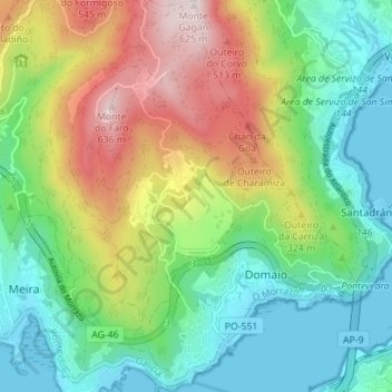
Name: Domaio topographic map, elevation, terrain.
Location: Domaio, Moaña, Morrazo, Pontevedra, Galicia, España (42.27903 -8.70802 42.33058 -8.65881)
Average elevation: 712 ft
Minimum elevation: -3 ft
Maximum elevation: 2,054 ft
Thank you for supporting this site ❤️
Make a donation
Make a donation
Gear up for your next adventure:
As an Amazon Associate, this site earns from qualifying purchases at no extra cost to you.