Geolocate

Balestrate topographic map

Click on the map to display elevation.

About this map

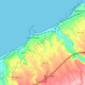
Name: Balestrate topographic map, elevation, terrain.

Location: Balestrate, Palermo, Sicily, 90041, Italy (38.03255 12.97659 38.06567 13.03736)

Average elevation: 135 ft

Minimum elevation: 0 ft

Maximum elevation: 489 ft

Other topographic maps

Click on a map to view its topography, its elevation and its terrain.

Sorgente di Montescuro

Italy > Sicily > Palermo > Prizzi

Average elevation: 2,726 ft

Bellacera

Italy > Sicily > Palermo > Santa Flavia

Average elevation: 531 ft

Finale

Italy > Sicily > Palermo

Average elevation: 276 ft

Santa Lucia

Italy > Sicily > Palermo > Cefalù

Average elevation: 167 ft

San Carlo

Italy > Sicily > Palermo > Chiusa Sclafani

Average elevation: 955 ft

Gear up for your next adventure:

🗺️NatGeo Topo Maps - High-quality waterproof printed topographic maps of US Parks
🔌USB Car Charger - Car charger for on‑the‑go power needs
🪄Magnetic Compass - Accurate compass for navigation
🌎3D Topographic Globes - Raised relief globes for a tactile understanding of geography
📻Weather Alert Radios - Stay informed of storm risks while off-the-grid

As an Amazon Associate, this site earns from qualifying purchases at no extra cost to you.