Geolocate

Angmering topographic map

Click on the map to display elevation.

About this map

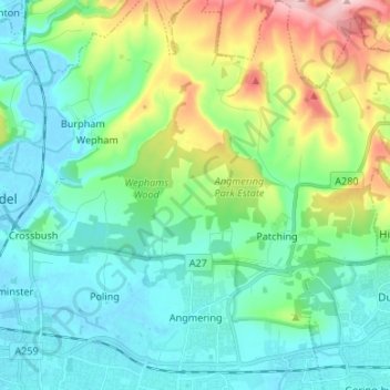
Name: Angmering topographic map, elevation, terrain.

Location: Angmering, Arun, West Sussex, England, United Kingdom (50.81260 -0.51563 50.89689 -0.45538)

Average elevation: 164 ft

Minimum elevation: -10 ft

Maximum elevation: 666 ft

Other topographic maps

Click on a map to view its topography, its elevation and its terrain.

Harrow Hill

United Kingdom > England > West Sussex > Arun

Average elevation: 348 ft

Felpham

United Kingdom > England > West Sussex > Arun > Felpham

Average elevation: 7 ft

Gear up for your next adventure:

🪑Ultralight Camp Chairs - Portable seating for resting after a long day of mapping
🧯Emergency Survival Kit - All‑in‑one survival essentials for the backcountry
🔦Compact Flashlight - Reliable flashlight for emergencies
🧭Hiking Compass - Precision compass for reliable navigation in the wilderness
Camping Coffee Makers - Enjoy premium coffee at the summit or campsite

As an Amazon Associate, this site earns from qualifying purchases at no extra cost to you.