
Make a donation
Gear up for your next adventure:
As an Amazon Associate, this site earns from qualifying purchases at no extra cost to you.
Lac Vert topographic map
Click on the map to display elevation.
Make a donation
Gear up for your next adventure:
As an Amazon Associate, this site earns from qualifying purchases at no extra cost to you.
About this map
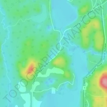
Name: Lac Vert topographic map, elevation, terrain.
Average elevation: 748 ft
Minimum elevation: 656 ft
Maximum elevation: 1,076 ft
Make a donation
Gear up for your next adventure:
As an Amazon Associate, this site earns from qualifying purchases at no extra cost to you.
Other topographic maps
Click on a map to view its topography, its elevation and its terrain.
Rivière du Lièvre
Canada > Québec > Antoine-Labelle > Notre-Dame-du-Laus
La Lièvre commence son cours à une altitude de 384 m au Lac Orthès qui est situé dans le territoire non organisé de Lac-Bazinet. Elle coule ensuite vers le sud sur 330 km pour se jeter dans la rivière des Outaouais à Gatineau dans le secteur Masson-Angers à une altitude de 44 m.
Average elevation: 896 ft
Make a donation
Gear up for your next adventure:
As an Amazon Associate, this site earns from qualifying purchases at no extra cost to you.