
Make a donation
Gear up for your next adventure:
As an Amazon Associate, this site earns from qualifying purchases at no extra cost to you.
Innenstadt topographic map
Click on the map to display elevation.
Make a donation
Gear up for your next adventure:
As an Amazon Associate, this site earns from qualifying purchases at no extra cost to you.
Innenstadt
Architekt Helmut Jahn sagte im Zusammenhang mit der Errichtung des Kölntriangle, dass ein Gebäude von mehr als 110 Metern Höhe „aus Respekt vor dem Dom“ nicht wünschenswert sei. Dementsprechend sieht das „Höhenkonzept“ der Stadt Köln vom Mai 2007 vor, dass Neubauten zwischen dem linken Rheinufer und der Außenkante der Kölner Ringe nicht höher als 22,50 Meter konzipiert sein dürfen. Für höhere Neubauten muss der Nachweis erbracht werden, dass der Blick auf den Dom und die romanischen Kirchen nicht beeinträchtigt wird.
Make a donation
Gear up for your next adventure:
As an Amazon Associate, this site earns from qualifying purchases at no extra cost to you.
About this map
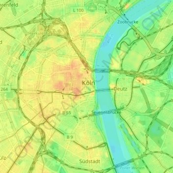
Name: Innenstadt topographic map, elevation, terrain.
Location: Innenstadt, Köln, Nordrhein-Westfalen, Deutschland (50.91539 6.92470 50.95929 6.99561)
Average elevation: 167 ft
Minimum elevation: 112 ft
Maximum elevation: 213 ft
Make a donation
Gear up for your next adventure:
As an Amazon Associate, this site earns from qualifying purchases at no extra cost to you.
Other topographic maps
Click on a map to view its topography, its elevation and its terrain.
Make a donation
Gear up for your next adventure:
As an Amazon Associate, this site earns from qualifying purchases at no extra cost to you.