
Make a donation
Gear up for your next adventure:
As an Amazon Associate, this site earns from qualifying purchases at no extra cost to you.
São Romão topographic map
Click on the map to display elevation.
Make a donation
Gear up for your next adventure:
As an Amazon Associate, this site earns from qualifying purchases at no extra cost to you.
São Romão
São Romão is located on the left bank of the São Francisco River at an elevation of 480 meters. It is north of the nearest population center, Pirapora. Montes Claros is to the southeast. Neighboring municipalities are: Riachinho, Santa Fé de Minas, Pintópolis, and Icaraí de Minas. São Romão is part of the statistical microregion of Pirapora. It is located 595 km from the capital of the state (Belo Horizonte).
Make a donation
Gear up for your next adventure:
As an Amazon Associate, this site earns from qualifying purchases at no extra cost to you.
About this map
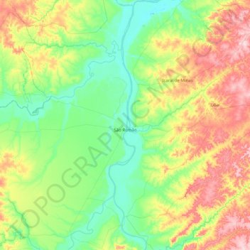
Name: São Romão topographic map, elevation, terrain.
Average elevation: 1,801 ft
Minimum elevation: 1,496 ft
Maximum elevation: 2,500 ft
Make a donation
Gear up for your next adventure:
As an Amazon Associate, this site earns from qualifying purchases at no extra cost to you.
Other topographic maps
Click on a map to view its topography, its elevation and its terrain.
Belo Horizonte
Brazil > Minas Gerais > Região Metropolitana de Belo Horizonte > Belo Horizonte
In 1893, due to the climatic and topographic conditions, Curral Del Rey was selected by Minas Gerais governor Afonso Pena among other cities as the location for the new economic and cultural center of the state, under the new name of Cidade de Minas, or City of Minas.
Average elevation: 2,966 ft