
Make a donation
Gear up for your next adventure:
As an Amazon Associate, this site earns from qualifying purchases at no extra cost to you.
Hartford topographic map
Click on the map to display elevation.
Make a donation
Gear up for your next adventure:
As an Amazon Associate, this site earns from qualifying purchases at no extra cost to you.
About this map
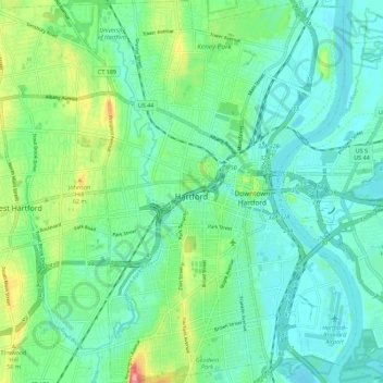
Name: Hartford topographic map, elevation, terrain.
Average elevation: 75 ft
Minimum elevation: 0 ft
Maximum elevation: 289 ft
Capitol Planning Region trails, hiking, mountain biking, running and outdoor activities
Make a donation
Gear up for your next adventure:
As an Amazon Associate, this site earns from qualifying purchases at no extra cost to you.
Other topographic maps
Click on a map to view its topography, its elevation and its terrain.
West Suffield
United States > Connecticut > Capitol Planning Region > Suffield
Average elevation: 194 ft
Plantsville
United States > Connecticut > Capitol Planning Region > Southington
Average elevation: 187 ft
Four Corners
United States > Connecticut > Capitol Planning Region > Terramuggus
Average elevation: 469 ft
Willington Hill
United States > Connecticut > Capitol Planning Region > Willington
Average elevation: 646 ft
Make a donation
Gear up for your next adventure:
As an Amazon Associate, this site earns from qualifying purchases at no extra cost to you.
Vernon Center
United States > Connecticut > Capitol Planning Region > Vernon
Average elevation: 348 ft
Griswoldville
United States > Connecticut > Capitol Planning Region > Wethersfield
Average elevation: 112 ft
Clay Arsenal
United States > Connecticut > Capitol Planning Region > Hartford
Average elevation: 59 ft
Make a donation
Gear up for your next adventure:
As an Amazon Associate, this site earns from qualifying purchases at no extra cost to you.
North End
United States > Connecticut > Capitol Planning Region > Southington
Average elevation: 223 ft
Chaffeeville
United States > Connecticut > Capitol Planning Region > Mansfield
Average elevation: 436 ft
West District
United States > Connecticut > Capitol Planning Region > Farmington
Average elevation: 302 ft
Talcott Mountain
United States > Connecticut > Capitol Planning Region > Bloomfield
Average elevation: 499 ft
Make a donation
Gear up for your next adventure:
As an Amazon Associate, this site earns from qualifying purchases at no extra cost to you.
South Wethersfield
United States > Connecticut > Capitol Planning Region > Wethersfield > Griswoldville
Average elevation: 72 ft
Bishop's Corner
United States > Connecticut > Capitol Planning Region > West Hartford
Average elevation: 154 ft
Buckingham
United States > Connecticut > Capitol Planning Region > Glastonbury
Average elevation: 430 ft
Make a donation
Gear up for your next adventure:
As an Amazon Associate, this site earns from qualifying purchases at no extra cost to you.
North Coventry
United States > Connecticut > Capitol Planning Region > Coventry
Average elevation: 640 ft
Talcott Mountain
United States > Connecticut > Capitol Planning Region > Bloomfield
Average elevation: 499 ft
Make a donation
Gear up for your next adventure:
As an Amazon Associate, this site earns from qualifying purchases at no extra cost to you.
Avon Park North
United States > Connecticut > Capitol Planning Region > Avon
Average elevation: 249 ft
Clay Arsenal
United States > Connecticut > Capitol Planning Region > Hartford
Average elevation: 59 ft
Make a donation
Gear up for your next adventure:
As an Amazon Associate, this site earns from qualifying purchases at no extra cost to you.
Holcomb Farm
United States > Connecticut > Capitol Planning Region > Granby > West Granby
Average elevation: 381 ft
Johnson Hill
United States > Connecticut > Capitol Planning Region > West Hartford
Average elevation: 112 ft
Unionville
United States > Connecticut > Capitol Planning Region > Farmington
Average elevation: 315 ft
Make a donation
Gear up for your next adventure:
As an Amazon Associate, this site earns from qualifying purchases at no extra cost to you.
Spoonville
United States > Connecticut > Capitol Planning Region > East Granby
Average elevation: 203 ft
Stafford Springs
United States > Connecticut > Capitol Planning Region > Stafford
Average elevation: 656 ft
Cottage Grove
United States > Connecticut > Capitol Planning Region > Bloomfield
Average elevation: 102 ft
Make a donation
Gear up for your next adventure:
As an Amazon Associate, this site earns from qualifying purchases at no extra cost to you.
Barbara Drive
United States > Connecticut > Capitol Planning Region > Windsor Locks
Average elevation: 128 ft
Unionville
United States > Connecticut > Capitol Planning Region > Farmington
Average elevation: 315 ft
Make a donation
Gear up for your next adventure:
As an Amazon Associate, this site earns from qualifying purchases at no extra cost to you.
Thompsonville
United States > Connecticut > Capitol Planning Region > Enfield
Average elevation: 105 ft