
Benfeita topographic map
Interactive map
Click on the map to display elevation.
About this map
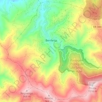
Name: Benfeita topographic map, elevation, terrain.
Average elevation: 1,936 ft
Minimum elevation: 666 ft
Maximum elevation: 3,291 ft
Other topographic maps
Click on a map to view its topography, its elevation and its terrain.
Serra do Açor Protected Landscape
Serra do Açor Protected Landscape, Moura da Serra, Benfeita, Arganil, Coimbra, Pinhal Interior Norte, Centro, 3305-031, Portugal
Average elevation: 2,060 ft