
Red Rocks topographic map
Click on the map to display elevation.
About this map
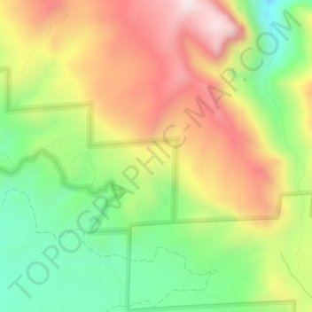
Name: Red Rocks topographic map, elevation, terrain.
Location: Red Rocks, Montrose County, Colorado, United States (38.57476 -107.80388 38.57486 -107.80378)
Average elevation: 6,788 ft
Minimum elevation: 5,889 ft
Maximum elevation: 7,789 ft
Montrose County trails, hiking, mountain biking, running and outdoor activities
Other topographic maps
Click on a map to view its topography, its elevation and its terrain.
Black Canyon of the Gunnison National Park
United States > Colorado > Montrose County
Average elevation: 7,300 ft
Black Canyon of the Gunnison Wilderness
United States > Colorado > Montrose County
Average elevation: 7,096 ft
Black Canyon of the Gunnison National Park
United States > Colorado > Montrose County
Average elevation: 7,300 ft