
Make a donation
Gear up for your next adventure:
As an Amazon Associate, this site earns from qualifying purchases at no extra cost to you.
Zandvoorde topographic map
Click on the map to display elevation.
Make a donation
Gear up for your next adventure:
As an Amazon Associate, this site earns from qualifying purchases at no extra cost to you.
Zandvoorde
Tijdens de volle middeleeuwen kennen bewoning in en ontginning van het landschap een versnellingsmoment, waarbij verschillende nederzettingen werden ingeplant. Een goed gekend voorbeeld van een dergelijke nederzetting is de vindplaatsencomplex Zegersdijk, een verdwenen middeleeuws gehucht in de Zwaanhoek. Ter hoogte van dit toponiem werden meerdere vindplaatsen uit de 10e-12e eeuw aangetroffen, evenals vervaagde infrastructuur (wegen en dijken).
Make a donation
Gear up for your next adventure:
As an Amazon Associate, this site earns from qualifying purchases at no extra cost to you.
About this map
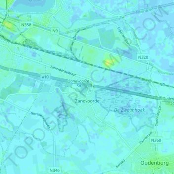
Name: Zandvoorde topographic map, elevation, terrain.
Location: Zandvoorde, Oostende, West-Vlaanderen, Vlaanderen, België (51.18581 2.92841 51.22342 3.00435)
Average elevation: 7 ft
Minimum elevation: -10 ft
Maximum elevation: 39 ft
Make a donation
Gear up for your next adventure:
As an Amazon Associate, this site earns from qualifying purchases at no extra cost to you.
Other topographic maps
Click on a map to view its topography, its elevation and its terrain.