
La Cara topographic map
Interactive map
Click on the map to display elevation.
About this map
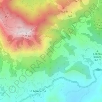
Name: La Cara topographic map, elevation, terrain.
Location: La Cara, Fortuna, Orientale, Région de Murcie, Espagne (38.24960 -1.19136 38.26960 -1.17136)
Average elevation: 2,556 ft
Minimum elevation: 1,654 ft
Maximum elevation: 4,075 ft
Other topographic maps
Click on a map to view its topography, its elevation and its terrain.
Caprés
Espagne > Région de Murcie > Fortuna > Caprés
Caprés, Fortuna, Orientale, Région de Murcie, 30626, Espagne
Average elevation: 1,549 ft