
Make a donation
Gear up for your next adventure:
As an Amazon Associate, this site earns from qualifying purchases at no extra cost to you.
High Uintas Wilderness topographic map
Click on the map to display elevation.
Make a donation
Gear up for your next adventure:
As an Amazon Associate, this site earns from qualifying purchases at no extra cost to you.
About this map
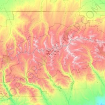
Name: High Uintas Wilderness topographic map, elevation, terrain.
Average elevation: 9,577 ft
Minimum elevation: 5,896 ft
Maximum elevation: 13,465 ft
Duchesne County trails, hiking, mountain biking, running and outdoor activities
Make a donation
Gear up for your next adventure:
As an Amazon Associate, this site earns from qualifying purchases at no extra cost to you.
Other topographic maps
Click on a map to view its topography, its elevation and its terrain.
Kings Peak
United States > Utah > Duchesne County
Kings Peak is the highest peak in the U.S. state of Utah, with an elevation of 13,528 feet (4,123 m) NAVD 88.
Average elevation: 12,280 ft