
Make a donation
Gear up for your next adventure:
As an Amazon Associate, this site earns from qualifying purchases at no extra cost to you.
Surajkund topographic map
Click on the map to display elevation.
Make a donation
Gear up for your next adventure:
As an Amazon Associate, this site earns from qualifying purchases at no extra cost to you.
Surajkund
In the Aravalli hill ranges, which spreads over Delhi and Haryana, where the Surajkund and the Anagpur Dam are located, ancient Stone Age relics have been revealed. The Aravallis, which strike out in two directions from Delhi exhibits a topography of low and rugged hills. The stratigraphy in the area is considered to consist of reddish rocks and scrub and has the luxuriance of the Stone Age progression. Stone Age material have been unearthed in the region at 43 sites on the road from Delhi to Surajkund and south of the Suraj Kund-Faridabad road, Anangpur hills and Ankhir pahari on the road on the low ridge from Faridabad to Surajkund. The Stone Age relics comprise Microliths and lower Paleolithics.
Make a donation
Gear up for your next adventure:
As an Amazon Associate, this site earns from qualifying purchases at no extra cost to you.
About this map
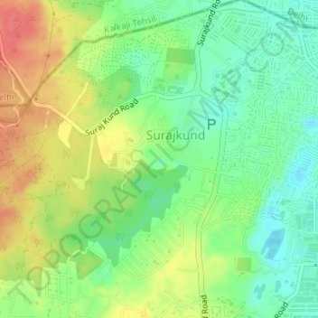
Name: Surajkund topographic map, elevation, terrain.
Location: Surajkund, Suraj Kund Road, Faridabad, Haryana, 121001, India (28.48303 77.28233 28.48448 77.28367)
Average elevation: 755 ft
Minimum elevation: 666 ft
Maximum elevation: 866 ft
Make a donation
Gear up for your next adventure:
As an Amazon Associate, this site earns from qualifying purchases at no extra cost to you.