Geolocate

Taytay topographic map

Click on the map to display elevation.

About this map

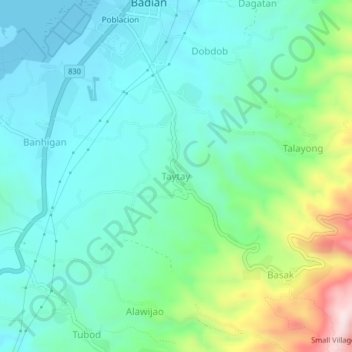
Name: Taytay topographic map, elevation, terrain.

Location: Taytay, Badian, Cebu, Central Visayas, 6031, Philippines (9.83032 123.38211 9.87032 123.42211)

Average elevation: 394 ft

Minimum elevation: -10 ft

Maximum elevation: 1,634 ft

Gear up for your next adventure:

🦟Ultrasonic Repellers - Create a bug-free zone at your camp or rest stop
🧣Merino Neck Gaiters - Multi-functional headwear for wind and sun protection
😴Insulated Sleeping Pads - Compact and warm pads for high-elevation camping
🪑Portable Camp Table - Compact table for campsite meals
🛠️Outdoor Gear Repair Kit - Essential tools to fix gear on the trail

As an Amazon Associate, this site earns from qualifying purchases at no extra cost to you.