
Thank you for supporting this site ❤️
Make a donation
Make a donation
Gear up for your next adventure:
As an Amazon Associate, this site earns from qualifying purchases at no extra cost to you.
Tivissa topographic map
Click on the map to display elevation.
Thank you for supporting this site ❤️
Make a donation
Make a donation
Gear up for your next adventure:
As an Amazon Associate, this site earns from qualifying purchases at no extra cost to you.
About this map
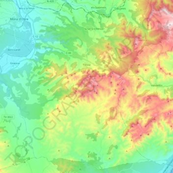
Name: Tivissa topographic map, elevation, terrain.
Location: Tivissa, Ribera d'Ebre, Tarragona, Catalonia, 43746, Spain (40.93218 0.63378 41.10504 0.87304)
Average elevation: 932 ft
Minimum elevation: 0 ft
Maximum elevation: 2,759 ft
Thank you for supporting this site ❤️
Make a donation
Make a donation
Gear up for your next adventure:
As an Amazon Associate, this site earns from qualifying purchases at no extra cost to you.