
Thank you for supporting this site ❤️
Make a donation
Make a donation
Gear up for your next adventure:
As an Amazon Associate, this site earns from qualifying purchases at no extra cost to you.
Valditacca topographic map
Click on the map to display elevation.
Thank you for supporting this site ❤️
Make a donation
Make a donation
Gear up for your next adventure:
As an Amazon Associate, this site earns from qualifying purchases at no extra cost to you.
About this map
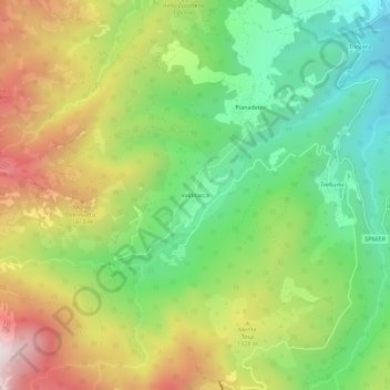
Name: Valditacca topographic map, elevation, terrain.
Location: Valditacca, Monchio delle Corti, Parma, Emilia-Romagna, Italia (44.36911 10.07835 44.40911 10.11835)
Average elevation: 3,786 ft
Minimum elevation: 2,493 ft
Maximum elevation: 5,597 ft
Thank you for supporting this site ❤️
Make a donation
Make a donation
Gear up for your next adventure:
As an Amazon Associate, this site earns from qualifying purchases at no extra cost to you.