
Make a donation
Gear up for your next adventure:
As an Amazon Associate, this site earns from qualifying purchases at no extra cost to you.
Hulst topographic map
Click on the map to display elevation.
Make a donation
Gear up for your next adventure:
As an Amazon Associate, this site earns from qualifying purchases at no extra cost to you.
Hulst
Hulst is gelegen op de grens van zeekleipoldergebied en hoger gelegen pleistoceen gebied, op een hoogte van ongeveer 2 meter. De historische kern is omringd door de stadsomwalling. Daarbuiten zijn meerdere woonwijken en een bedrijventerrein gebouwd. Ook is er veel bos aangelegd in het noordoosten en het zuidoosten van de oude kern. Naar het westen toe verloopt de Oude Vaart, een voormalige scheepvaartweg die naar het natuurgebied Groot Eiland loopt. Naar het noordoosten loopt de Liniedijk, met bastions en het voormalige Fort Moerschans. Verder vindt men langs de Liniedijk nog restanten van Fort De Rape en Fort Zandberg. Parallel aan de Liniedijk loopt de Moerschans, die in verbinding staat met een krekensysteem, dat de Berriekreek, de Zandbergsche Kreek, de Rotte Kreek, de Kleine Kreek, de Zestig Voet, de Vuilmuil en de Vlaamsche Kreek. Naar het zuiden toe vindt men restanten van de Gentsevaart die de stad verbond met Gent via de Moervaart en de toenmalige Sassevaart (nu kanaal Gent-Terneuzen). Het tracé liep van de wijk Zoetevaart langs rijksweg 60 en het gehucht Kapellebrug naar Fort Sint-Jan in België om dan vervolgens zuidwestwaarts af te buigen naar Stekene en de Stekense Vaart (wat althans het laatste nog bestaande deel is van deze vaart).
Make a donation
Gear up for your next adventure:
As an Amazon Associate, this site earns from qualifying purchases at no extra cost to you.
About this map
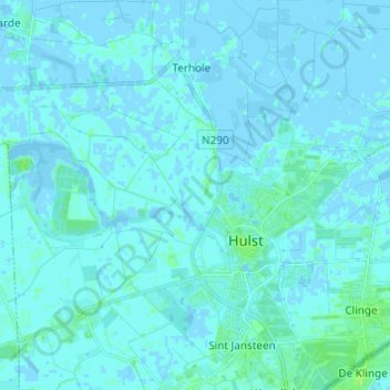
Name: Hulst topographic map, elevation, terrain.
Location: Hulst, Zeeland, Nederland (51.25712 3.97817 51.32499 4.09995)
Average elevation: 3 ft
Minimum elevation: -13 ft
Maximum elevation: 26 ft
Make a donation
Gear up for your next adventure:
As an Amazon Associate, this site earns from qualifying purchases at no extra cost to you.
Other topographic maps
Click on a map to view its topography, its elevation and its terrain.
Make a donation
Gear up for your next adventure:
As an Amazon Associate, this site earns from qualifying purchases at no extra cost to you.
Make a donation
Gear up for your next adventure:
As an Amazon Associate, this site earns from qualifying purchases at no extra cost to you.
Make a donation
Gear up for your next adventure:
As an Amazon Associate, this site earns from qualifying purchases at no extra cost to you.
Make a donation
Gear up for your next adventure:
As an Amazon Associate, this site earns from qualifying purchases at no extra cost to you.
Make a donation
Gear up for your next adventure:
As an Amazon Associate, this site earns from qualifying purchases at no extra cost to you.
Make a donation
Gear up for your next adventure:
As an Amazon Associate, this site earns from qualifying purchases at no extra cost to you.
Sint Anna ter Muiden
Sint Anna ter Muiden ligt in het zeekleipoldergebied op een hoogte van ongeveer 1,5 meter. In de omgeving vindt men diverse historische polderdijken die ook de Belgisch-Nederlandse grens overschrijden. In het zuiden ligt de Damse Vaart en in het nabijgelegen België vindt men kreken en overblijfselen van de…
Average elevation: 3 ft
Make a donation
Gear up for your next adventure:
As an Amazon Associate, this site earns from qualifying purchases at no extra cost to you.
Make a donation
Gear up for your next adventure:
As an Amazon Associate, this site earns from qualifying purchases at no extra cost to you.
Make a donation
Gear up for your next adventure:
As an Amazon Associate, this site earns from qualifying purchases at no extra cost to you.
Make a donation
Gear up for your next adventure:
As an Amazon Associate, this site earns from qualifying purchases at no extra cost to you.
Make a donation
Gear up for your next adventure:
As an Amazon Associate, this site earns from qualifying purchases at no extra cost to you.
Cadzand-Bad
Na de watersnoodramp van 1953 werd de haven gedempt en werd een dijk van 9 meter hoogte aangelegd. Ook kwam er een nieuwe zeesluis.
Average elevation: 3 ft
Make a donation
Gear up for your next adventure:
As an Amazon Associate, this site earns from qualifying purchases at no extra cost to you.