
Thank you for supporting this site ❤️
Make a donation
Make a donation
Gear up for your next adventure:
As an Amazon Associate, this site earns from qualifying purchases at no extra cost to you.
Malcas topographic map
Click on the map to display elevation.
Thank you for supporting this site ❤️
Make a donation
Make a donation
Gear up for your next adventure:
As an Amazon Associate, this site earns from qualifying purchases at no extra cost to you.
About this map
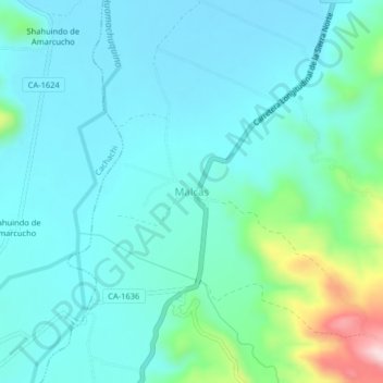
Name: Malcas topographic map, elevation, terrain.
Location: Malcas, Condebamba, Cajabamba, Cajamarca, Perú (-7.53003 -78.16370 -7.49003 -78.12370)
Average elevation: 6,795 ft
Minimum elevation: 6,588 ft
Maximum elevation: 7,733 ft
Thank you for supporting this site ❤️
Make a donation
Make a donation
Gear up for your next adventure:
As an Amazon Associate, this site earns from qualifying purchases at no extra cost to you.