
Make a donation
Gear up for your next adventure:
As an Amazon Associate, this site earns from qualifying purchases at no extra cost to you.
Wesergebirge topographic map
Click on the map to display elevation.
Make a donation
Gear up for your next adventure:
As an Amazon Associate, this site earns from qualifying purchases at no extra cost to you.
Wesergebirge
Das Wesergebirge, das in den Landkreisen Minden-Lübbecke, Schaumburg, Hameln-Pyrmont liegt, erstreckt sich etwa in Westnordwest-Ostsüdost-Richtung von der Stadt Porta Westfalica bzw. vom Weserdurchbruch Porta Westfalica im Westen nördlich über Rinteln und Hessisch Oldendorf bis zum Höhenschwerpunkt des Süntel um die Hohe Egge nördlich Hamelns und unmittelbar südwestlich von Bad Münder. Es ist Teil der Abgrenzung des Weserberglands und damit einer Teilregion der deutschen Mittelgebirge im Süden zur Norddeutschen Tiefebene im Norden.
Make a donation
Gear up for your next adventure:
As an Amazon Associate, this site earns from qualifying purchases at no extra cost to you.
About this map
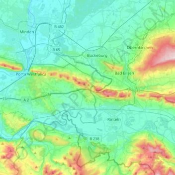
Name: Wesergebirge topographic map, elevation, terrain.
Average elevation: 351 ft
Minimum elevation: 118 ft
Maximum elevation: 1,198 ft
Make a donation
Gear up for your next adventure:
As an Amazon Associate, this site earns from qualifying purchases at no extra cost to you.
Other topographic maps
Click on a map to view its topography, its elevation and its terrain.
Kleinenbremen
Deutschland > Nordrhein-Westfalen > Kreis Minden-Lübbecke > Porta Westfalica
Average elevation: 430 ft
Porta Westfalica
Deutschland > Nordrhein-Westfalen > Kreis Minden-Lübbecke > Porta Westfalica
Average elevation: 262 ft
Barksen
Deutschland > Nordrhein-Westfalen > Kreis Minden-Lübbecke > Porta Westfalica
Average elevation: 453 ft
Vennebeck
Deutschland > Nordrhein-Westfalen > Kreis Minden-Lübbecke > Porta Westfalica
Average elevation: 190 ft
Make a donation
Gear up for your next adventure:
As an Amazon Associate, this site earns from qualifying purchases at no extra cost to you.
Vennebeckerbruch
Deutschland > Nordrhein-Westfalen > Kreis Minden-Lübbecke > Porta Westfalica
Average elevation: 282 ft