
Thank you for supporting this site ❤️
Make a donation
Make a donation
Gear up for your next adventure:
As an Amazon Associate, this site earns from qualifying purchases at no extra cost to you.
眉山乡 topographic map
Click on the map to display elevation.
Thank you for supporting this site ❤️
Make a donation
Make a donation
Gear up for your next adventure:
As an Amazon Associate, this site earns from qualifying purchases at no extra cost to you.
眉山乡
眉山乡為中國福建省泉州市南安市的一個鄉,位於南安市的西北部。由於山區地形像是眉毛,故名為「眉山」。
Thank you for supporting this site ❤️
Make a donation
Make a donation
Gear up for your next adventure:
As an Amazon Associate, this site earns from qualifying purchases at no extra cost to you.
About this map
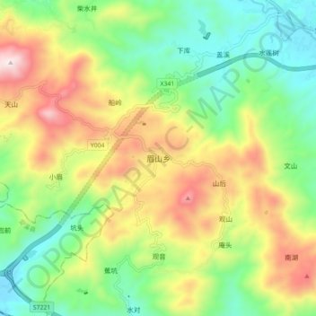
Name: 眉山乡 topographic map, elevation, terrain.
Location: 眉山乡, 南安市, 泉州市, 福建省, 中国 (25.04772 118.26580 25.12772 118.34580)
Average elevation: 1,227 ft
Minimum elevation: 121 ft
Maximum elevation: 2,930 ft
Thank you for supporting this site ❤️
Make a donation
Make a donation
Gear up for your next adventure:
As an Amazon Associate, this site earns from qualifying purchases at no extra cost to you.
Other topographic maps
Click on a map to view its topography, its elevation and its terrain.