
Thank you for supporting this site ❤️
Make a donation
Make a donation
Gear up for your next adventure:
As an Amazon Associate, this site earns from qualifying purchases at no extra cost to you.
Laxmangarh topographic map
Click on the map to display elevation.
Thank you for supporting this site ❤️
Make a donation
Make a donation
Gear up for your next adventure:
As an Amazon Associate, this site earns from qualifying purchases at no extra cost to you.
Laxmangarh
Laxmangarh is located at 27°49′21″N 75°01′31″E / 27.8225°N 75.025278°E / 27.8225; 75.025278. It has an average elevation of 222 metres (728 ft).
Thank you for supporting this site ❤️
Make a donation
Make a donation
Gear up for your next adventure:
As an Amazon Associate, this site earns from qualifying purchases at no extra cost to you.
About this map
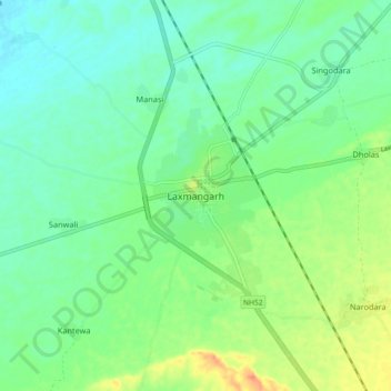
Name: Laxmangarh topographic map, elevation, terrain.
Average elevation: 1,181 ft
Minimum elevation: 1,132 ft
Maximum elevation: 1,283 ft
Thank you for supporting this site ❤️
Make a donation
Make a donation
Gear up for your next adventure:
As an Amazon Associate, this site earns from qualifying purchases at no extra cost to you.