Geolocate

Mingo topographic map

Interactive map

Click on the map to display elevation.

About this map

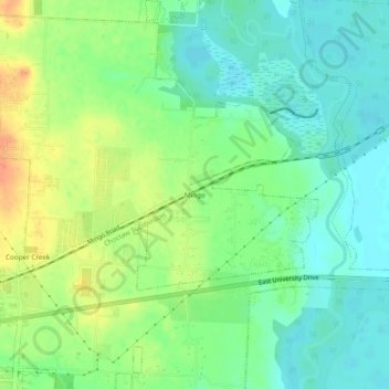
Name: Mingo topographic map, elevation, terrain.

Location: Mingo, Denton, Denton County, Texas, 76298, United States (33.22679 -97.08084 33.26679 -97.04084)

Average elevation: 564 ft

Minimum elevation: 509 ft

Maximum elevation: 656 ft

Other topographic maps

Click on a map to view its topography, its elevation and its terrain.

Cooper Creek

United States > Texas > Denton County > Denton

Cooper Creek, Denton, Denton County, Texas, 76298, United States

Average elevation: 604 ft

Green Valley

United States > Texas > Denton County > Denton

Green Valley, Denton, Denton County, Texas, United States

Average elevation: 591 ft

North Pointe Park

United States > Texas > Denton County > Denton

North Pointe Park, Denton, Denton County, Texas, 76201, United States

Average elevation: 689 ft

South Lakes Park

United States > Texas > Denton County > Denton

South Lakes Park, Denton, Denton County, Texas, 76205, United States

Average elevation: 659 ft

Mayhill

United States > Texas > Denton County > Denton

Mayhill, Denton, Denton County, Texas, 76208, United States

Average elevation: 600 ft