
Thank you for supporting this site ❤️
Make a donation
Make a donation
Gear up for your next adventure:
As an Amazon Associate, this site earns from qualifying purchases at no extra cost to you.
Hiriyur topographic map
Click on the map to display elevation.
Thank you for supporting this site ❤️
Make a donation
Make a donation
Gear up for your next adventure:
As an Amazon Associate, this site earns from qualifying purchases at no extra cost to you.
Hiriyur
Hiriyur is located at 13°57′N 76°37′E / 13.95°N 76.62°E / 13.95; 76.62. It has an average elevation of 630 metres (2066 feet). The months of March and April are the hottest months of the year.
Thank you for supporting this site ❤️
Make a donation
Make a donation
Gear up for your next adventure:
As an Amazon Associate, this site earns from qualifying purchases at no extra cost to you.
About this map
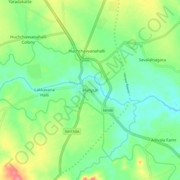
Name: Hiriyur topographic map, elevation, terrain.
Average elevation: 2,011 ft
Minimum elevation: 1,919 ft
Maximum elevation: 2,192 ft
Thank you for supporting this site ❤️
Make a donation
Make a donation
Gear up for your next adventure:
As an Amazon Associate, this site earns from qualifying purchases at no extra cost to you.