
Medusa topographic map
Click on the map to display elevation.
Medusa
Medusa is located at 42°26′12″N 074°07′48″W / 42.43667°N 74.13000°W / 42.43667; -74.13000 (42.4367469, -74.1301365) and its elevation is 804 feet (245 m).
About this map
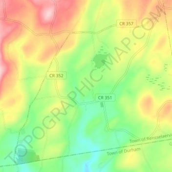
Name: Medusa topographic map, elevation, terrain.
Average elevation: 974 ft
Minimum elevation: 659 ft
Maximum elevation: 1,362 ft
Albany County trails, hiking, mountain biking, running and outdoor activities
Other topographic maps
Click on a map to view its topography, its elevation and its terrain.
Cooksburg
United States > New York > Albany County > Town of Rensselaerville
Average elevation: 1,089 ft