Geolocate

Danforth topographic map

Click on the map to display elevation.

About this map

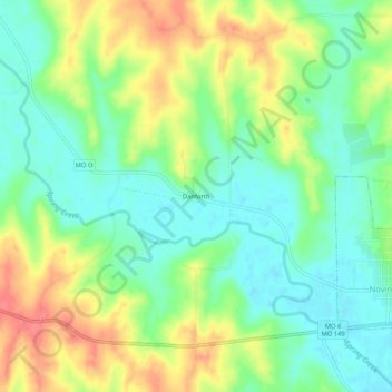
Name: Danforth topographic map, elevation, terrain.

Location: Danforth, Adair County, Missouri, 63559, United States (40.22142 -92.75409 40.26142 -92.71409)

Average elevation: 843 ft

Minimum elevation: 755 ft

Maximum elevation: 974 ft

Adair County trails, hiking, mountain biking, running and outdoor activities

Other topographic maps

Click on a map to view its topography, its elevation and its terrain.

Brashear

United States > Missouri > Adair County

Average elevation: 843 ft

Novinger

United States > Missouri > Adair County

Average elevation: 797 ft

Gibbs

United States > Missouri > Adair County

Average elevation: 896 ft

Gear up for your next adventure:

🎒Outdoor Daypacks - Lightweight backpacks designed for carrying maps and essential gear
🩹Survival Bandages - High‑quality bandages for emergencies
🧯Portable Fire Pit - Compact fire pit for camping spots
🧥Men's Rain Shells - Premium waterproof and breathable jackets for mountain weather
🔥Fast-Boil Camping Stoves - Efficient cooking systems for quick trail meals

As an Amazon Associate, this site earns from qualifying purchases at no extra cost to you.