Geolocate

Nind topographic map

Click on the map to display elevation.

About this map

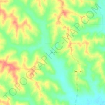
Name: Nind topographic map, elevation, terrain.

Location: Nind, Adair County, Missouri, United States (40.05058 -92.78797 40.09058 -92.74797)

Average elevation: 876 ft

Minimum elevation: 774 ft

Maximum elevation: 991 ft

Adair County trails, hiking, mountain biking, running and outdoor activities

Other topographic maps

Click on a map to view its topography, its elevation and its terrain.

Novinger

United States > Missouri > Adair County

Average elevation: 797 ft

Gibbs

United States > Missouri > Adair County

Average elevation: 896 ft

Brashear

United States > Missouri > Adair County

Average elevation: 843 ft

Gear up for your next adventure:

🔋Solar Power Banks - Keep your GPS and phone charged in remote wilderness areas
📚Navigation Handbooks - Master the art of reading topographic maps and using a compass
🧤Tactile Hiking Gloves - Keep hands warm while operating GPS and smartphone screens
🌧️Backpack Rain Cover - Keep gear dry in wet weather
📌Outdoor GPS Map App - Apps and devices for digital topographic navigation

As an Amazon Associate, this site earns from qualifying purchases at no extra cost to you.