Geolocate

Pinkneyville topographic map

Click on the map to display elevation.

About this map

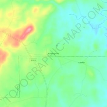
Name: Pinkneyville topographic map, elevation, terrain.

Location: Pinkneyville, Clay County, Alabama, 35702, United States (33.08679 -85.97913 33.12679 -85.93913)

Average elevation: 748 ft

Minimum elevation: 607 ft

Maximum elevation: 1,033 ft

Clay County trails, hiking, mountain biking, running and outdoor activities

Other topographic maps

Click on a map to view its topography, its elevation and its terrain.

Delta

United States > Alabama > Clay County

Average elevation: 997 ft

Talladega Mountain

United States > Alabama > Clay County

Average elevation: 1,109 ft

Gear up for your next adventure:

🧦Merino Wool Socks - Moisture-wicking, blister-preventing socks for long treks
Backpacking Tents - Weight-optimized shelters for multi-day topographic surveys
🥤Water Filter Bottle - All‑in‑one filter bottle for safe hydration
❄️Traction Cleats - Prevent slips on icy trails during winter hikes
🎒Day Hiking Backpack - Lightweight backpack perfect for day trips and outdoor adventures

As an Amazon Associate, this site earns from qualifying purchases at no extra cost to you.