Geolocate

Springhill topographic map

Click on the map to display elevation.

About this map

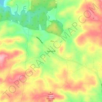
Name: Springhill topographic map, elevation, terrain.

Location: Springhill, Clay County, Alabama, United States (33.29039 -85.94191 33.33039 -85.90191)

Average elevation: 1,204 ft

Minimum elevation: 919 ft

Maximum elevation: 1,453 ft

Clay County trails, hiking, mountain biking, running and outdoor activities

Other topographic maps

Click on a map to view its topography, its elevation and its terrain.

Delta

United States > Alabama > Clay County

Average elevation: 997 ft

Talladega Mountain

United States > Alabama > Clay County

Average elevation: 1,109 ft

Gear up for your next adventure:

🪶Wildlife Field Guides - Learn animal tracking and species ID
🧣Hiking Neck Gaiter - Multi‑use neck protection for outdoor weather
🛌Ultralight Sleeping Bags - Compact down bags for cold nights in the wilderness
🥘Titanium Cookware - Durable, featherlight pots and pans for backpacking
🛡️Insect Repellent - Protection against bugs during outdoor activities

As an Amazon Associate, this site earns from qualifying purchases at no extra cost to you.