
Thank you for supporting this site ❤️
Make a donation
Make a donation
Gear up for your next adventure:
As an Amazon Associate, this site earns from qualifying purchases at no extra cost to you.
Linate topographic map
Click on the map to display elevation.
Thank you for supporting this site ❤️
Make a donation
Make a donation
Gear up for your next adventure:
As an Amazon Associate, this site earns from qualifying purchases at no extra cost to you.
About this map
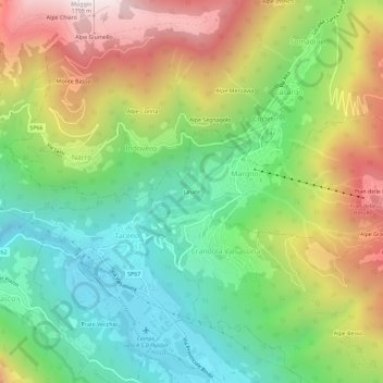
Name: Linate topographic map, elevation, terrain.
Location: Linate, Margno, Lecco, Lombardia, 23832, Italia (46.00907 9.35369 46.04907 9.39369)
Average elevation: 3,009 ft
Minimum elevation: 1,316 ft
Maximum elevation: 5,571 ft
Thank you for supporting this site ❤️
Make a donation
Make a donation
Gear up for your next adventure:
As an Amazon Associate, this site earns from qualifying purchases at no extra cost to you.