
Make a donation
Gear up for your next adventure:
As an Amazon Associate, this site earns from qualifying purchases at no extra cost to you.
Aegina topographic map
Click on the map to display elevation.
Make a donation
Gear up for your next adventure:
As an Amazon Associate, this site earns from qualifying purchases at no extra cost to you.
About this map
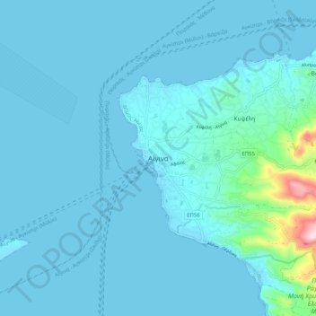
Name: Aegina topographic map, elevation, terrain.
Average elevation: 89 ft
Minimum elevation: -7 ft
Maximum elevation: 1,198 ft
Make a donation
Gear up for your next adventure:
As an Amazon Associate, this site earns from qualifying purchases at no extra cost to you.
Other topographic maps
Click on a map to view its topography, its elevation and its terrain.
Antikythera
Greece > Attica > Regional Unit of Islands > Municipal Unit of Antikythira
Average elevation: 98 ft
Poros
Greece > Attica > Regional Unit of Islands > Poros
The land area of the municipality (which includes the islands and part of the adjacent Peloponnese coast) is 49.582 square kilometres (19.144 sq mi). The landscape is very hilly and mountainous. The highest peak is the Vigla (358 m) in the west-central part. Following the island's topography and geology, small…
Average elevation: 102 ft
Make a donation
Gear up for your next adventure:
As an Amazon Associate, this site earns from qualifying purchases at no extra cost to you.
Salamis
Greece > Attica > Regional Unit of Islands > Ampelakia Municipal Unit
Average elevation: 125 ft