Geolocate

Bucksnort topographic map

Click on the map to display elevation.

About this map

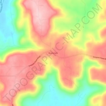
Name: Bucksnort topographic map, elevation, terrain.

Location: Bucksnort, Marshall County, Alabama, 35747, United States (34.48314 -86.32387 34.52314 -86.28387)

Average elevation: 948 ft

Minimum elevation: 558 ft

Maximum elevation: 1,253 ft

Marshall County trails, hiking, mountain biking, running and outdoor activities

Other topographic maps

Click on a map to view its topography, its elevation and its terrain.

Douglas

United States > Alabama > Marshall County

Average elevation: 906 ft

Union Grove

United States > Alabama > Marshall County

Union Grove is located in western Marshall County at 34°24′0″N 86°26′46″W / 34.40000°N 86.44611°W / 34.40000; -86.44611 (34.400088, -86.446049). It is 7 miles (11 km) northeast of Arab and 5 miles (8 km) southwest of Guntersville Dam on the Tennessee River. Union Grove sits at an elevation…

Average elevation: 997 ft

Grant

United States > Alabama > Marshall County

Grant is located in northeastern Marshall County at an elevation of 1,240 feet (380 m) on the plateau of Gunters Mountain. The town is concentrated along County Road 5 (Cathedral Caverns Highway, signed as Main Street in Grant) near the northern edge of Gunters Mountain, though the town includes corridors…

Average elevation: 984 ft

Shoal Creek

United States > Alabama > Marshall County > Arab

Average elevation: 1,073 ft

Boaz

United States > Alabama > Marshall County

Average elevation: 1,053 ft

Union Grove

United States > Alabama > Marshall County

Union Grove is located in western Marshall County at 34°24′0″N 86°26′46″W / 34.40000°N 86.44611°W / 34.40000; -86.44611 (34.400088, -86.446049). It is 7 miles (11 km) northeast of Arab and 5 miles (8 km) southwest of Guntersville Dam on the Tennessee River. Union Grove sits at an elevation…

Average elevation: 981 ft

Gear up for your next adventure:

🧭GPS Watch Accessories - Bands and chargers for GPS watches
🥇GPS Hiking Watch - Multi‑sport GPS watch with navigation and trail tracking
Backpacking Tents - Weight-optimized shelters for multi-day topographic surveys
🪓Survival Multi‑Tool - Versatile tool for camp and trail tasks
💧Water Purification System - Clean water on the trail with reliable purifiers

As an Amazon Associate, this site earns from qualifying purchases at no extra cost to you.