
Thank you for supporting this site ❤️
Make a donation
Make a donation
Gear up for your next adventure:
As an Amazon Associate, this site earns from qualifying purchases at no extra cost to you.
Coclesito topographic map
Click on the map to display elevation.
Thank you for supporting this site ❤️
Make a donation
Make a donation
Gear up for your next adventure:
As an Amazon Associate, this site earns from qualifying purchases at no extra cost to you.
About this map
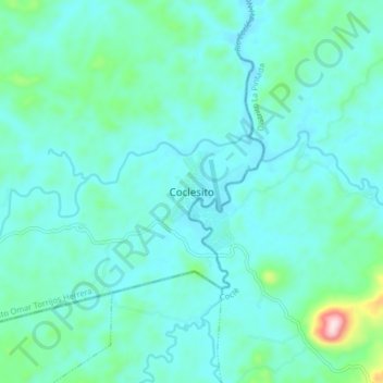
Name: Coclesito topographic map, elevation, terrain.
Location: Coclesito, Distrito Omar Torrijos Herrera, Colón, Panamá (8.76988 -80.59568 8.84988 -80.51568)
Average elevation: 246 ft
Minimum elevation: 66 ft
Maximum elevation: 1,306 ft
Thank you for supporting this site ❤️
Make a donation
Make a donation
Gear up for your next adventure:
As an Amazon Associate, this site earns from qualifying purchases at no extra cost to you.