Geolocate

Milford topographic map

Click on the map to display elevation.

About this map

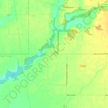
Name: Milford topographic map, elevation, terrain.

Location: Milford, Decatur County, Indiana, United States (39.33024 -85.63823 39.37024 -85.59823)

Average elevation: 846 ft

Minimum elevation: 791 ft

Maximum elevation: 886 ft

Decatur County trails, hiking, mountain biking, running and outdoor activities

Other topographic maps

Click on a map to view its topography, its elevation and its terrain.

Lake Santee

United States > Indiana > Decatur County

Average elevation: 1,007 ft

St. Paul

United States > Indiana > Decatur County

Average elevation: 846 ft

Westport

United States > Indiana > Decatur County

Average elevation: 817 ft

Millhousen

United States > Indiana > Decatur County

Average elevation: 909 ft

New Point

United States > Indiana > Decatur County

Average elevation: 988 ft

Gear up for your next adventure:

📡Handheld GPS Device - Reliable handheld GPS for outdoor navigation
👟Men's Trail Runners - Lightweight footwear for fast-paced exploration and light hiking
🧦Hiking Socks - Comfortable socks to prevent blisters on long hikes
🧭Compass with Lanyard - Easy‑carry compass for navigation
🦟Ultrasonic Repellers - Create a bug-free zone at your camp or rest stop

As an Amazon Associate, this site earns from qualifying purchases at no extra cost to you.