
高城镇 topographic map
Interactive map
Click on the map to display elevation.
About this map
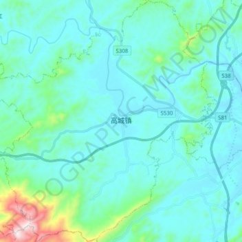
Name: 高城镇 topographic map, elevation, terrain.
Location: 高城镇, 万载县, 宜春市, 江西省, 中国 (28.03486 114.26870 28.16979 114.41164)
Average elevation: 623 ft
Minimum elevation: 266 ft
Maximum elevation: 3,068 ft
Other topographic maps
Click on a map to view its topography, its elevation and its terrain.