
Make a donation
Gear up for your next adventure:
As an Amazon Associate, this site earns from qualifying purchases at no extra cost to you.
Rodenäs topographic map
Click on the map to display elevation.
Make a donation
Gear up for your next adventure:
As an Amazon Associate, this site earns from qualifying purchases at no extra cost to you.
Rodenäs
Der Boden wird, aufgrund des jeweiligen Alters seit Eindeichung, heute überwiegend als Kleimarsch klassifiziert. Aufgrund des absolut flachen Reliefs, ebenso wie aufgrund der niedrigen Lage in Küstennähe auf oder knapp unter der Meeresspiegelhöhe im Hinterland des Nordfriesischen Wattenmeeres, ist am Ort eine aktive Entwässerung des Gemeindegebiets eine grundlegende Notwendigkeit für die landwirtschaftliche Nutzung im Bereich des Ackerbaus. Für die Entwässerung sind ordnungsrechtlich sogenannte Sielverbände verantwortlich. Für das Gemeindegebiet sind dies im Einzelnen.
Make a donation
Gear up for your next adventure:
As an Amazon Associate, this site earns from qualifying purchases at no extra cost to you.
About this map
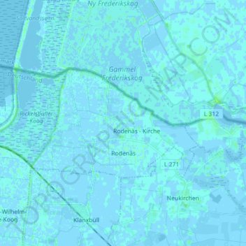
Name: Rodenäs topographic map, elevation, terrain.
Average elevation: 0 ft
Minimum elevation: -13 ft
Maximum elevation: 20 ft
Make a donation
Gear up for your next adventure:
As an Amazon Associate, this site earns from qualifying purchases at no extra cost to you.
Other topographic maps
Click on a map to view its topography, its elevation and its terrain.
Bundesgaard
Deutschland > Schleswig-Holstein > Kreis Nordfriesland > Neukirchen
Average elevation: -3 ft
Make a donation
Gear up for your next adventure:
As an Amazon Associate, this site earns from qualifying purchases at no extra cost to you.
Archsum
Deutschland > Schleswig-Holstein > Kreis Nordfriesland > Sylt
Landwirtschaft und Seefahrt bildeten sehr lange die Lebensgrundlage der Archsumer Bewohner. 1611 wurden 38 Hofstellen gezählt, etwa 150 Menschen lebten im Dorf. 1709 gab es 42 Höfe und acht selbstständige Katen. 25 Männer und 53 Familien fuhren zu dieser Zeit als Seeleute auf der Nordsee. Die Abhängigkeit…
Average elevation: 3 ft
Make a donation
Gear up for your next adventure:
As an Amazon Associate, this site earns from qualifying purchases at no extra cost to you.
Nordermitteldeich
Deutschland > Schleswig-Holstein > Kreis Nordfriesland > Pellworm
Average elevation: -3 ft
Make a donation
Gear up for your next adventure:
As an Amazon Associate, this site earns from qualifying purchases at no extra cost to you.
Eiderstedt
Deutschland > Schleswig-Holstein > Kreis Nordfriesland > Poppenbüll
Average elevation: 0 ft
Make a donation
Gear up for your next adventure:
As an Amazon Associate, this site earns from qualifying purchases at no extra cost to you.
Bollhaus
Deutschland > Schleswig-Holstein > Kreis Nordfriesland > Süder-Waygaard
Average elevation: -7 ft
Bohmstedtfeld
Deutschland > Schleswig-Holstein > Kreis Nordfriesland > Bohmstedt
Average elevation: 30 ft
Ellenbogen
Deutschland > Schleswig-Holstein > Kreis Nordfriesland > List auf Sylt
Average elevation: 3 ft
Make a donation
Gear up for your next adventure:
As an Amazon Associate, this site earns from qualifying purchases at no extra cost to you.
Norderoog
Deutschland > Schleswig-Holstein > Kreis Nordfriesland > Hallig Hooge
Average elevation: 0 ft
Archsum
Deutschland > Schleswig-Holstein > Kreis Nordfriesland > Sylt
Landwirtschaft und Seefahrt bildeten sehr lange die Lebensgrundlage der Archsumer Bewohner. 1611 wurden 38 Hofstellen gezählt, etwa 150 Menschen lebten im Dorf. 1709 gab es 42 Höfe und acht selbstständige Katen. 25 Männer und 53 Familien fuhren zu dieser Zeit als Seeleute auf der Nordsee. Die Abhängigkeit…
Average elevation: 3 ft
Make a donation
Gear up for your next adventure:
As an Amazon Associate, this site earns from qualifying purchases at no extra cost to you.