
Make a donation
Gear up for your next adventure:
As an Amazon Associate, this site earns from qualifying purchases at no extra cost to you.
Grundlsee topographic map
Click on the map to display elevation.
Make a donation
Gear up for your next adventure:
As an Amazon Associate, this site earns from qualifying purchases at no extra cost to you.
Grundlsee
The climate in Grundlsee is determined by its geographical location in the Aussee Basin. It is characterized mainly by the high altitude and the location in the northern congestion area. The result is, in the case of flow conditions from the west to the north, often days of precipitation, which in winter are accompanied by a lot of snow. With 100 to 120 days of snow cover per year, the Ausseer Becken is one of the snowiest areas in Austria. From October to May, snowfall is expected, with December to March, on average, every third day has fresh snow. Fall has a relative sunshine duration over 50%, the sunniest time in the region. The climate in the Ausseer basin is often described as a stimulating climate, especially in winter.
Make a donation
Gear up for your next adventure:
As an Amazon Associate, this site earns from qualifying purchases at no extra cost to you.
About this map
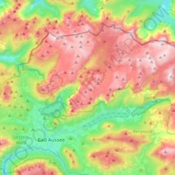
Name: Grundlsee topographic map, elevation, terrain.
Location: Grundlsee, Bezirk Liezen, Styria, 8993, Austria (47.60658 13.79339 47.71765 14.05543)
Average elevation: 4,068 ft
Minimum elevation: 1,824 ft
Maximum elevation: 6,919 ft
Make a donation
Gear up for your next adventure:
As an Amazon Associate, this site earns from qualifying purchases at no extra cost to you.
Other topographic maps
Click on a map to view its topography, its elevation and its terrain.