
Make a donation
Gear up for your next adventure:
As an Amazon Associate, this site earns from qualifying purchases at no extra cost to you.
Ironsides topographic map
Click on the map to display elevation.
Make a donation
Gear up for your next adventure:
As an Amazon Associate, this site earns from qualifying purchases at no extra cost to you.
Ironsides
Ironsides is a populated place located within the township of Schuylkill in Chester County, Pennsylvania, United States. It has an estimated elevation of 118 feet (36 m) above sea level.
Make a donation
Gear up for your next adventure:
As an Amazon Associate, this site earns from qualifying purchases at no extra cost to you.
About this map
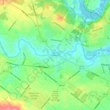
Name: Ironsides topographic map, elevation, terrain.
Average elevation: 200 ft
Minimum elevation: 89 ft
Maximum elevation: 384 ft
Chester County trails, hiking, mountain biking, running and outdoor activities
Make a donation
Gear up for your next adventure:
As an Amazon Associate, this site earns from qualifying purchases at no extra cost to you.