
Make a donation
Gear up for your next adventure:
As an Amazon Associate, this site earns from qualifying purchases at no extra cost to you.
Oberschöna topographic map
Click on the map to display elevation.
Make a donation
Gear up for your next adventure:
As an Amazon Associate, this site earns from qualifying purchases at no extra cost to you.
Oberschöna
Das Waldhufendorf Oberschöna liegt im Osterzgebirge, 6 km westlich von Freiberg, 6 km nördlich von Brand-Erbisdorf und 30 km östlich von Chemnitz in einer Höhenlage von 350 m bis 390 m über NN. Die Gemeinde befindet sich im Tal der Großen Striegis. Durch den Ort führt die Bundesstraße 173, eine Staatsstraße führt nach Brand-Erbisdorf.
Make a donation
Gear up for your next adventure:
As an Amazon Associate, this site earns from qualifying purchases at no extra cost to you.
About this map
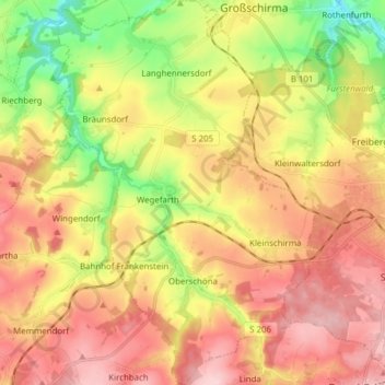
Name: Oberschöna topographic map, elevation, terrain.
Location: Oberschöna, Mittelsachsen, Sachsen, 09600, Deutschland (50.87120 13.19911 50.96817 13.30405)
Average elevation: 1,309 ft
Minimum elevation: 951 ft
Maximum elevation: 1,617 ft
Make a donation
Gear up for your next adventure:
As an Amazon Associate, this site earns from qualifying purchases at no extra cost to you.