
Thank you for supporting this site ❤️
Make a donation
Make a donation
Gear up for your next adventure:
As an Amazon Associate, this site earns from qualifying purchases at no extra cost to you.
Oberlangkampfen topographic map
Click on the map to display elevation.
Thank you for supporting this site ❤️
Make a donation
Make a donation
Gear up for your next adventure:
As an Amazon Associate, this site earns from qualifying purchases at no extra cost to you.
About this map
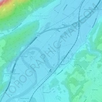
Name: Oberlangkampfen topographic map, elevation, terrain.
Location: Oberlangkampfen, Langkampfen, Bezirk Kufstein, 6322, Austria (47.50414 12.06801 47.54414 12.10801)
Average elevation: 1,791 ft
Minimum elevation: 1,585 ft
Maximum elevation: 3,885 ft
Thank you for supporting this site ❤️
Make a donation
Make a donation
Gear up for your next adventure:
As an Amazon Associate, this site earns from qualifying purchases at no extra cost to you.