Geolocate

Karyzhyn topographic map

Click on the map to display elevation.

About this map

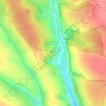
Name: Karyzhyn topographic map, elevation, terrain.

Location: Karyzhyn, Vinkivtsi Settlement Hromada, Khmelnytskyi Raion, Khmelnytskyi Oblast, 32506, Ukraine (48.97906 27.22401 49.00799 27.24435)

Average elevation: 915 ft

Minimum elevation: 735 ft

Maximum elevation: 1,066 ft

Other topographic maps

Click on a map to view its topography, its elevation and its terrain.

Sataniv

Ukraine > Khmelnytskyi Oblast

Average elevation: 1,020 ft

Starokostiantyniv

Ukraine > Khmelnytskyi Oblast

Average elevation: 922 ft

Kotelianka

Ukraine > Khmelnytskyi Oblast

Average elevation: 850 ft

Netishyn

Ukraine > Khmelnytskyi Oblast

Average elevation: 705 ft

Yampil

Ukraine > Khmelnytskyi Oblast

The city is located along Horyn River, a tributary of the Pripyat, and is part of the Podolsk Plateau [uk], while straddling the border with Lesser Polissia.[uk] Yampol is located in the more elevated part of Khmelnytskyi Oblast, in the Volyn highlands, where the average elevation is 329 meters above sea level.

Average elevation: 830 ft

Schasnivka

Ukraine > Khmelnytskyi Oblast > Schasnivka

Average elevation: 994 ft

Subich

Ukraine > Khmelnytskyi Oblast

Average elevation: 761 ft

Kamianets-Podilskyi

Ukraine > Khmelnytskyi Oblast

Average elevation: 719 ft

Gear up for your next adventure:

☀️Outdoor Sunscreen - High protection sunscreen for outdoor activities
🧤Hiking Gloves - Protective gloves for rugged trails
Backpacking Tents - Weight-optimized shelters for multi-day topographic surveys
🔦Compact Flashlight - Reliable flashlight for emergencies
🌡️Portable Weather Meter - Track weather conditions on the trail

As an Amazon Associate, this site earns from qualifying purchases at no extra cost to you.