
Make a donation
Gear up for your next adventure:
As an Amazon Associate, this site earns from qualifying purchases at no extra cost to you.
Lilydale topographic map
Click on the map to display elevation.
Make a donation
Gear up for your next adventure:
As an Amazon Associate, this site earns from qualifying purchases at no extra cost to you.
About this map
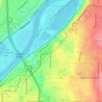
Name: Lilydale topographic map, elevation, terrain.
Location: Lilydale, Dakota County, Minnesota, United States (44.89247 -93.15336 44.91985 -93.10981)
Average elevation: 843 ft
Minimum elevation: 689 ft
Maximum elevation: 1,053 ft
Dakota County trails, hiking, mountain biking, running and outdoor activities
Make a donation
Gear up for your next adventure:
As an Amazon Associate, this site earns from qualifying purchases at no extra cost to you.
Other topographic maps
Click on a map to view its topography, its elevation and its terrain.
Burnsville
United States > Minnesota > Dakota County > Burnsville > Burnsville
Average elevation: 902 ft
Make a donation
Gear up for your next adventure:
As an Amazon Associate, this site earns from qualifying purchases at no extra cost to you.
Farmington
United States > Minnesota > Dakota County > Farmington > Farmington
Average elevation: 919 ft
Make a donation
Gear up for your next adventure:
As an Amazon Associate, this site earns from qualifying purchases at no extra cost to you.