Geolocate

Pittsburg topographic map

Click on the map to display elevation.

👉 Easily get elevation data in JSON, GeoTIFF and KML formats using Elevation API
Thank you for supporting this site ❤️
Make a donation

About this map

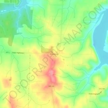
Name: Pittsburg topographic map, elevation, terrain.

Location: Pittsburg, Hickory County, Missouri, 65724, United States (37.81811 -93.31763 37.85811 -93.27763)

Average elevation: 955 ft

Minimum elevation: 833 ft

Maximum elevation: 1,129 ft

Hickory County trails, hiking, mountain biking, running and outdoor activities

Other topographic maps

Click on a map to view its topography, its elevation and its terrain.

Wheatland

United States > Missouri > Hickory County

Average elevation: 1,047 ft

Wheatland

United States > Missouri > Hickory County > Wheatland

Average elevation: 1,047 ft

Gear up for your next adventure:

🔦Powerful Headlamps - Ultra-bright hands-free lighting for night navigation
🧦Hiking Socks - Comfortable socks to prevent blisters on long hikes
🧤Tactile Hiking Gloves - Keep hands warm while operating GPS and smartphone screens
🔪Outdoor Multitools - Essential survival tools for gear repair and field use
🩳Quick‑Dry Hiking Shorts - Comfortable and quick‑dry shorts for summer hiking

As an Amazon Associate, this site earns from qualifying purchases at no extra cost to you.