Geolocate

Chendamangalam topographic map

Click on the map to display elevation.

About this map
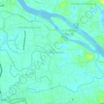
Name: Chendamangalam topographic map, elevation, terrain.

Location: Chendamangalam, Paravur, Ernakulam District, Kerala, 683512, India (10.14917 76.21409 10.18917 76.25409)

Average elevation: 16 ft

Minimum elevation: -13 ft

Maximum elevation: 69 ft

Other topographic maps

Click on a map to view its topography, its elevation and its terrain.
Kadungalloor

India > Kerala > Paravur > Edayar

Average elevation: 26 ft

Gear up for your next adventure:

🪶Compact Camp Shovel - Folding shovel for campsite tasks
🌐World Map Poster - Decorative world maps with topographic info
📶Satellite Messenger - Communication device off‑grid
🧭Pro Hiking Compasses - High-accuracy liquid-filled compasses for topographic orientation
🌲Outdoor Survival Books - Best books on survival skills

As an Amazon Associate, this site earns from qualifying purchases at no extra cost to you.