Geolocate

Chendamangalam topographic map

Click on the map to display elevation.

About this map

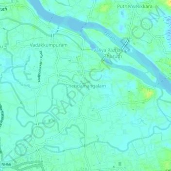
Name: Chendamangalam topographic map, elevation, terrain.

Location: Chendamangalam, Paravur, Ernakulam District, Kerala, 683512, India (10.14917 76.21409 10.18917 76.25409)

Average elevation: 16 ft

Minimum elevation: -13 ft

Maximum elevation: 69 ft

Other topographic maps

Click on a map to view its topography, its elevation and its terrain.

Kadungalloor

India > Kerala > Paravur > Edayar

Average elevation: 26 ft

Gear up for your next adventure:

🪑Ultralight Camp Chairs - Portable seating for resting after a long day of mapping
🔥Fast-Boil Camping Stoves - Efficient cooking systems for quick trail meals
🛡️Insect Repellent - Protection against bugs during outdoor activities
🧭Hiking Compass - Precision compass for reliable navigation in the wilderness
🗺️Topographic Maps - Detailed topo maps for hiking, exploring and outdoor navigation

As an Amazon Associate, this site earns from qualifying purchases at no extra cost to you.