Geolocate

Dajiang topographic map

Click on the map to display elevation.

About this map

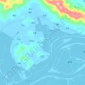
Name: Dajiang topographic map, elevation, terrain.

Location: Dajiang, Taishan, Jiangmen, Guangdong Province, China (21.93025 112.43128 21.97025 112.47128)

Average elevation: 62 ft

Minimum elevation: -13 ft

Maximum elevation: 699 ft

Gear up for your next adventure:

🌎3D Topographic Globes - Raised relief globes for a tactile understanding of geography
📚Navigation Handbooks - Master the art of reading topographic maps and using a compass
🧼Biodegradable Camping Soap - Eco‑friendly soap for outdoor hygiene
🔊Portable Camp Speaker - Music and alerts at camp
🪶Wildlife Field Guides - Learn animal tracking and species ID

As an Amazon Associate, this site earns from qualifying purchases at no extra cost to you.