
Make a donation
Gear up for your next adventure:
As an Amazon Associate, this site earns from qualifying purchases at no extra cost to you.
Hintersee topographic map
Click on the map to display elevation.
Make a donation
Gear up for your next adventure:
As an Amazon Associate, this site earns from qualifying purchases at no extra cost to you.
About this map
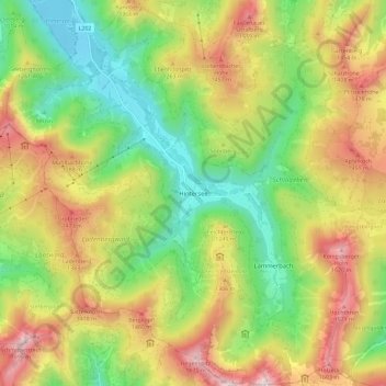
Name: Hintersee topographic map, elevation, terrain.
Location: Hintersee, Bezirk Salzburg-Umgebung, Salzburg, 5324, Austria (47.67465 13.23237 47.75206 13.34025)
Average elevation: 3,665 ft
Minimum elevation: 2,234 ft
Maximum elevation: 5,561 ft
Make a donation
Gear up for your next adventure:
As an Amazon Associate, this site earns from qualifying purchases at no extra cost to you.
Other topographic maps
Click on a map to view its topography, its elevation and its terrain.
Wallersee
Austria > Salzburg > Bezirk Salzburg-Umgebung > Seekirchen am Wallersee > Fischtaging
Average elevation: 1,742 ft
Make a donation
Gear up for your next adventure:
As an Amazon Associate, this site earns from qualifying purchases at no extra cost to you.
Gruberfeldsiedlung
Austria > Salzburg > Bezirk Salzburg-Umgebung > Heuberg
Average elevation: 2,260 ft
Make a donation
Gear up for your next adventure:
As an Amazon Associate, this site earns from qualifying purchases at no extra cost to you.
Achleiten
Austria > Salzburg > Bezirk Salzburg-Umgebung > Hof bei Salzburg
Average elevation: 2,188 ft
Make a donation
Gear up for your next adventure:
As an Amazon Associate, this site earns from qualifying purchases at no extra cost to you.