
Make a donation
Gear up for your next adventure:
As an Amazon Associate, this site earns from qualifying purchases at no extra cost to you.
Wals topographic map
Click on the map to display elevation.
Make a donation
Gear up for your next adventure:
As an Amazon Associate, this site earns from qualifying purchases at no extra cost to you.
About this map
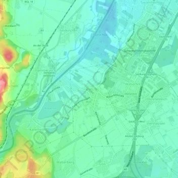
Name: Wals topographic map, elevation, terrain.
Average elevation: 1,444 ft
Minimum elevation: 1,362 ft
Maximum elevation: 1,703 ft
Make a donation
Gear up for your next adventure:
As an Amazon Associate, this site earns from qualifying purchases at no extra cost to you.
Other topographic maps
Click on a map to view its topography, its elevation and its terrain.
Wallersee
Austria > Salzburg > Bezirk Salzburg-Umgebung > Seekirchen am Wallersee > Fischtaging
Average elevation: 1,742 ft
Make a donation
Gear up for your next adventure:
As an Amazon Associate, this site earns from qualifying purchases at no extra cost to you.
Make a donation
Gear up for your next adventure:
As an Amazon Associate, this site earns from qualifying purchases at no extra cost to you.
Achleiten
Austria > Salzburg > Bezirk Salzburg-Umgebung > Hof bei Salzburg
Average elevation: 2,188 ft
Lake Wolfgang
Austria > Salzburg > Bezirk Salzburg-Umgebung > Sankt Gilgen
Average elevation: 2,769 ft
Make a donation
Gear up for your next adventure:
As an Amazon Associate, this site earns from qualifying purchases at no extra cost to you.