
Thank you for supporting this site ❤️
Make a donation
Make a donation
Gear up for your next adventure:
As an Amazon Associate, this site earns from qualifying purchases at no extra cost to you.
Mosorrofa topographic map
Click on the map to display elevation.
Thank you for supporting this site ❤️
Make a donation
Make a donation
Gear up for your next adventure:
As an Amazon Associate, this site earns from qualifying purchases at no extra cost to you.
About this map
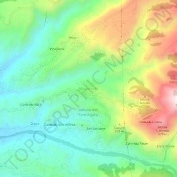
Name: Mosorrofa topographic map, elevation, terrain.
Location: Mosorrofa, Reggio Calabria, Calabria, 89126, Italia (38.07762 15.70534 38.11762 15.74534)
Average elevation: 1,519 ft
Minimum elevation: 600 ft
Maximum elevation: 3,202 ft
Thank you for supporting this site ❤️
Make a donation
Make a donation
Gear up for your next adventure:
As an Amazon Associate, this site earns from qualifying purchases at no extra cost to you.