Geolocate

Appledore topographic map

Click on the map to display elevation.

About this map
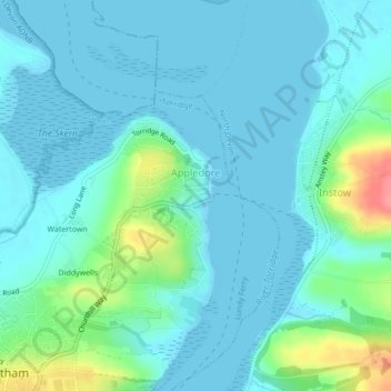
Name: Appledore topographic map, elevation, terrain.

Location: Appledore, Northam, Torridge District, Devon, Devon and Torbay, England, United Kingdom (51.04514 -4.20334 51.05939 -4.18333)

Average elevation: 49 ft

Minimum elevation: -3 ft

Maximum elevation: 266 ft

Other topographic maps

Click on a map to view its topography, its elevation and its terrain.
Diddywells

United Kingdom > England > Devon > Torridge District > Northam

Average elevation: 62 ft

Diddywells

United Kingdom > England > Devon > Torridge District > Northam

Average elevation: 62 ft

Gear up for your next adventure:

🧭Hiking Compass - Precision compass for reliable navigation in the wilderness
🏫Relief Map Kits - Hands-on tools for teaching landforms and elevation
🧭Pro Hiking Compasses - High-accuracy liquid-filled compasses for topographic orientation
🛰️Handheld GPS Units - Professional satellite navigators for precise backcountry mapping
📶Satellite Messenger - Communication device off‑grid

As an Amazon Associate, this site earns from qualifying purchases at no extra cost to you.