
Make a donation
Gear up for your next adventure:
As an Amazon Associate, this site earns from qualifying purchases at no extra cost to you.
Shangri-La topographic map
Click on the map to display elevation.
Make a donation
Gear up for your next adventure:
As an Amazon Associate, this site earns from qualifying purchases at no extra cost to you.
Shangri-La
Shangri-La has either a dry-winter, warm-summer humid continental climate (Köppen climate classification: Dwb), or a dry-winter subtropical highland climate (Köppen climate classification: Cwb), both of which are unusually cool by Yunnan standards due to the high elevation, which ranges between 2,700 and 3,500 metres (8,900 and 11,500 ft). Winters are chilly but sunny, with a January 24-hour average temperature of −2.3 °C (27.9 °F), while summers are cool, with a July 24-hour average temperature of 13.9 °C (57.0 °F), and feature frequent rain; more than 70% of the annual precipitation is delivered from June to September. The annual mean is 6.32 °C (43.4 °F). Except during the summer, nights are usually sharply cooler than the days. Despite the dryness of the winter, the small amount of precipitation is generally sufficient to cause major transportation dislocations and isolate the area between November and March.
Make a donation
Gear up for your next adventure:
As an Amazon Associate, this site earns from qualifying purchases at no extra cost to you.
About this map
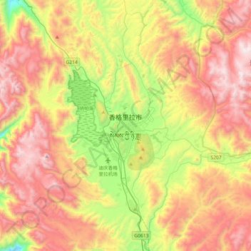
Name: Shangri-La topographic map, elevation, terrain.
Average elevation: 12,054 ft
Minimum elevation: 9,285 ft
Maximum elevation: 14,869 ft
Make a donation
Gear up for your next adventure:
As an Amazon Associate, this site earns from qualifying purchases at no extra cost to you.